Radar-estimated hail
nationalstorms.com · Sample report
Old Red Courthouse, Dallas (a landmark, not a home): radar-estimated hail, May 18, 2022
Home › Hail History Report
Hail History Report
Every day NOAA radar estimated hail near one US address since October 2019, and every storm report within 5 miles since 1955, in one report you can print or send.
$19 one time, for one addressReports open soon. The free check works now.
You'll see the free hail check first. Buy the report from there if you want it.
Pay on Stripe's secure pageReport opens right awayPDF by email
· As you type, the text is sent to Google to suggest addresses.IndependentNot affiliated with NOAA or the National Weather Service. Public NOAA and US Census data only. Methodology
Pages from a sample report
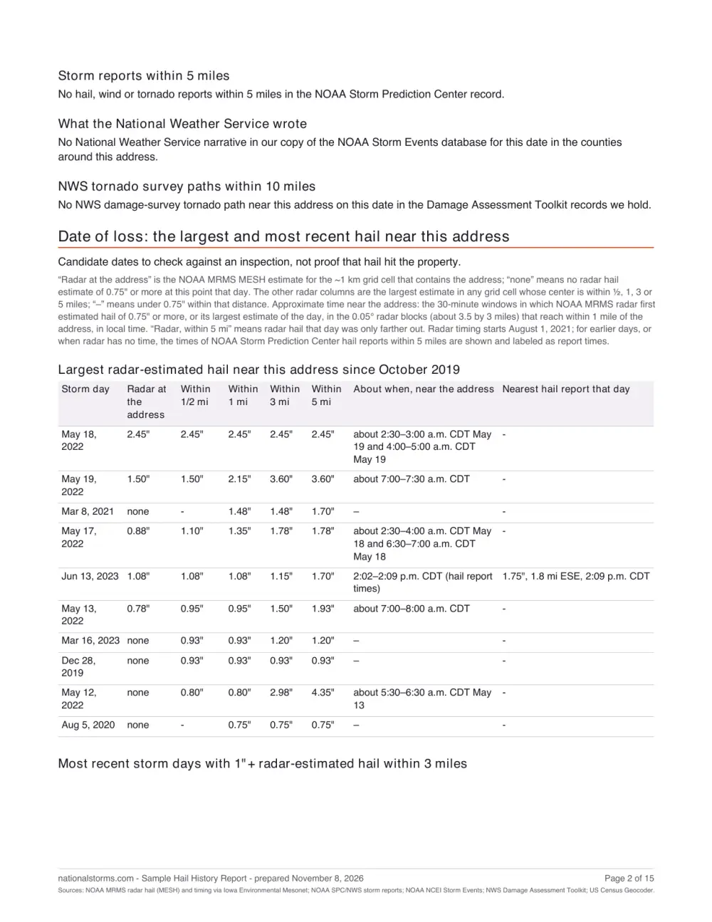
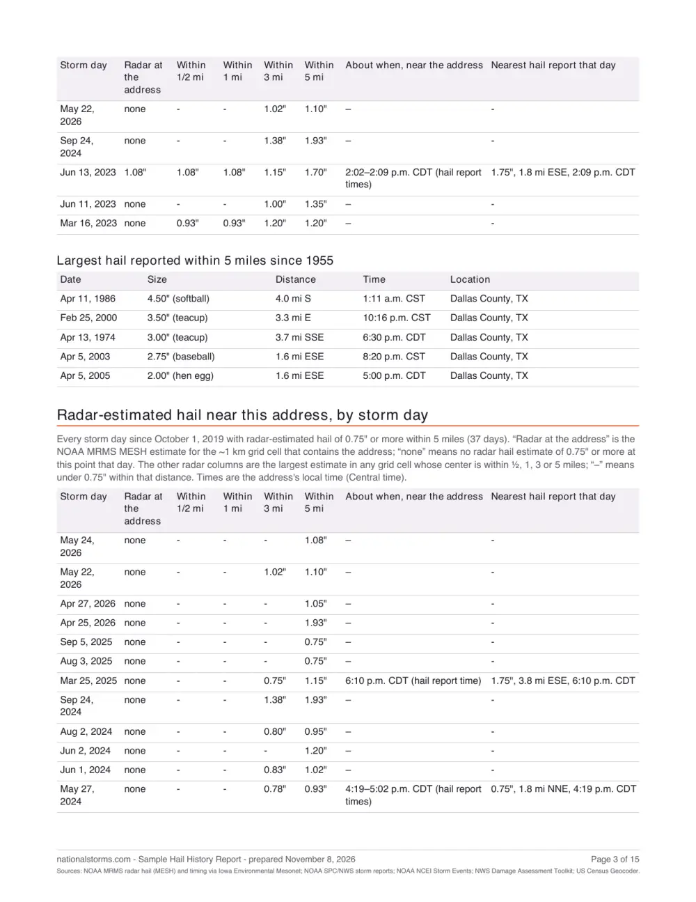
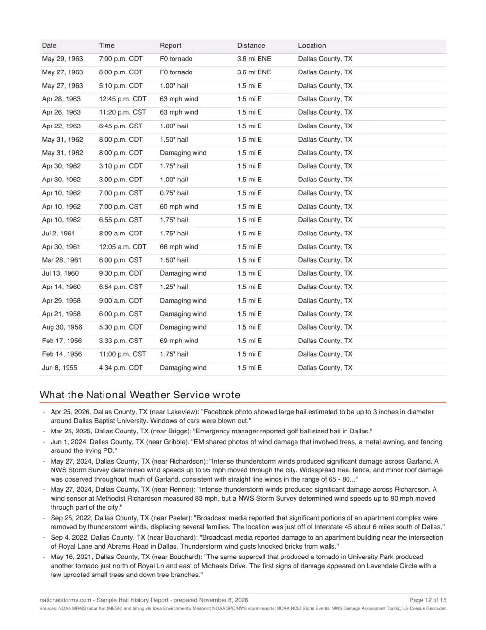
This sample is the real report, run for a public landmark, not a home: Old Red Courthouse, Dallas, Texas. A report you buy has the same sections for your address. Open the full sample · Sample PDF
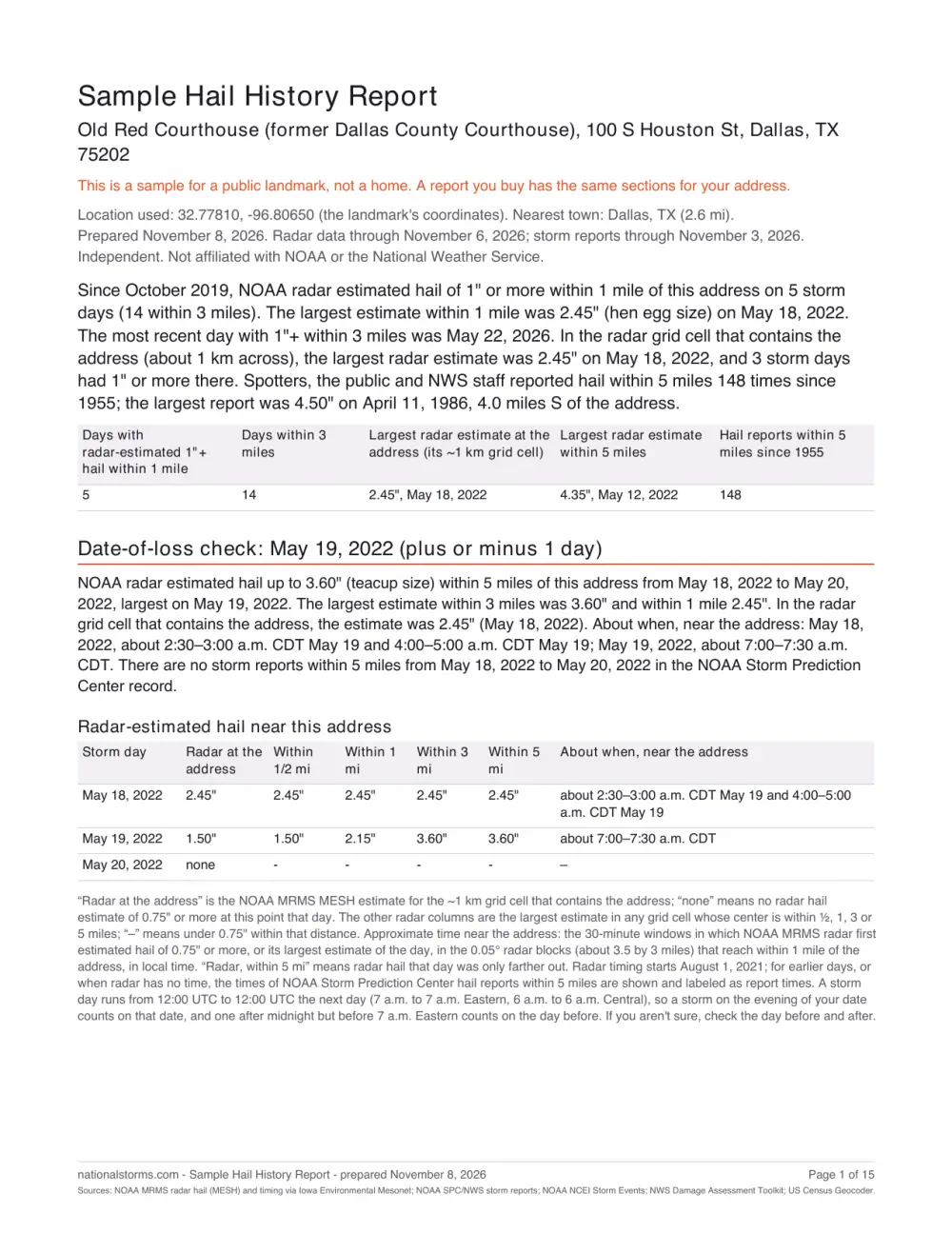
- The summaryHow many storm days radar estimated 1″+ hail within 1 and 3 miles, the largest at the address, and the hail reported within 5 miles since 1955.
- A date-of-loss checkFor the storm date you give: radar hail at the address and within ½, 1, 3 and 5 miles that day and the days around it.
- About when it fellThe half hour radar first saw hail near the address, in local time.
- Open the full sample
Free check or report
| Free check | Report, $19 | |
|---|---|---|
| Storm days with radar-estimated hail since October 2019 | The dates, marked within 1 or 3 miles | Every day, with the size at the address and within ½, 1, 3 and 5 miles |
| About when the hail fell | – | To about half an hour, from August 2021 |
| Storm reports within 5 miles since 1955 | How many | Each one, with size or speed, distance, direction and time |
| Date-of-loss check for a storm date | – | Yes, and you can rerun it for other dates |
| National Weather Service narratives | – | Yes, for nearby counties |
| NWS tornado survey paths | – | Within 5 miles |
| Printable PDF by email, link that works for 2 years | – | Yes |
Who uses it
Homeowners filing a claim
Check the storm date your insurer asks about, with radar hail near the address, nearby reports and what the National Weather Service wrote.
Buyers and sellers
A record of every hail day near the address since 2019 and every storm report since 1955, for an inspection or your files.
Roofers and adjusters
Reports for many addresses, with your name on them: see National Storms Pro.
How it works
- Enter the address. The US Census Bureau geocoder finds it. The address never goes in a link.
- See the free check. Storm days and a map of radar-estimated hail near the address.
- Get the report for $19. Pay on Stripe's secure page; the report opens right away and we email you the link and a PDF.
Questions
Does the report show that hail hit my roof?
No. It shows radar-estimated hail sizes for grid cells about 1 km across and storm reports at points nearby. It can't show whether hail hit or damaged a roof, a car or anything else. Use it alongside an inspection and your insurer's records.
What if radar found little or no hail near my address?
The free check shows that before you pay, so you can decide. A report with little or no hail isn't a reason for a refund; a double charge, a report that never loads or an address placed in the wrong spot is. Refund policy
How accurate is radar-estimated hail?
NOAA's MESH estimates the largest hail aloft in each ~1 km cell. It can run high or low, so the report puts it next to the ground reports from spotters and NWS staff. What MESH is and isn't · Methodology
Which addresses does it cover?
Any US street address. Radar hail estimates cover the lower 48 states from October 2019; storm reports cover every state since 1955.
Can I check one storm date?
Yes. Add the date with the address, or enter it later on the report page. The report checks that day and the day before and after.
What happens to my address?
It goes in the form, never in a link. We send it only to the US Census Bureau's geocoder to find its location, and we keep it with your order so your report link keeps working for 2 years. Stripe handles payment and your email for the receipt. To have an order deleted sooner, reply to your receipt email.
Check your address
Free first. The report is $19 if you want it.
Where the data comes from
Only public data: NOAA radar hail estimates (MRMS MESH), NOAA Storm Prediction Center storm reports, NOAA NCEI Storm Events, NWS damage surveys, and the US Census Bureau geocoder. See Methodology & sources.
What this is and isn't. This report lists radar-estimated hail sizes and public storm reports near this address. Radar estimates are for ~1 km grid cells around the location, not measurements at the property, and reports are what spotters, the public and NWS staff reported at points nearby. Nothing here shows whether hail hit or damaged a roof, a car or anything else. Use it alongside an inspection and your insurer's records. It is not an engineering, insurance or legal opinion. Disclaimer
Sources
- Radar hail: NOAA Multi-Radar Multi-Sensor (MRMS) Maximum Estimated Size of Hail (MESH), daily maximum on a 0.01° grid (about 1 km), from the Iowa Environmental Mesonet archive, October 2019 to date.
- Radar hail timing: NOAA MRMS MESH 24-hour running maximum, every 30 minutes, from the Iowa Environmental Mesonet archive, August 2021 to date.
- Storm reports and report times: NOAA Storm Prediction Center (SPC) severe weather database (hail and wind from 1955, tornadoes from 1950) and SPC preliminary daily reports for the latest year, from National Weather Service offices.
- Narratives, damage: NOAA National Centers for Environmental Information (NCEI) Storm Events Database, as entered by National Weather Service offices.
- Tornado surveys: NOAA National Weather Service Damage Assessment Toolkit (preliminary survey paths).
- Location: US Census Bureau Geocoder (public address ranges).
All data are public NOAA and US Census Bureau records. National Storms is independent and not affiliated with NOAA, the National Weather Service or any government agency.